Driving South through Canada’s
Yukon, British Columbia, and Alberta
Tuesday - Saturday, August 07 - 11, 2018
Smoky, 82°
The view that lay before us in the evening light was one that does not often fall to the lot of modern mountaineers. A new world was spread at our feet: to the westward stretched a vast ice-field probably never before seen by the human eye, and surrounded by entirely unknown, unnamed and unclimbed peaks. - July 1898, British explorer J. Norman Collie
Tuesday - The morning leaving Carmacks was cloudy with smoke in the air as the drive down the Klondike Highway wound its way along the Yukon River.

Yukon Territory Sign
There was only a stop to refuel in Whitehorse after entering the Alaska Highway on the way to Watson Lake. It’s a pretty drive but this trip the smoke from the nearby fires clouds the beauty of the local mountains. In the RV, it is about a six hour drive to Watson Lake. We pass several beautiful large lakes and rivers. Marsh and Teslin Lakes and the Swift River are beautiful places; there is only one drawback, they are miles from anywhere. If you lived in Alaska or the Lower 48 the only “quick” way to access the area is flying into Whitehorse and getting a vehicle to experience the great fishing or boating activities found here.
Watson Lake is another village I have enjoyed over the many travels along the Alaska Highway I have made over the years. There is a nice surprise found in the town’s park.

Watson Lake Sign Forest Sign
In 1942, while building the Alaska Hwy, it was common practice for the US Army of Engineers to put up a directional post at their camps. It gave directions and mileage to surrounding communities and various parts of the world. You will notice that the directional sign for Watson Lake points North with a distance of eight miles. In 1942 there was no town site here as there is today, but a Military Air Base and airport on Watson Lake.
While working on the Alcan Highway near Lower Post, BC, Private Carl K. Lindley from Company D, 341st Army of Engineers was injured and taken to the Army Aid Station in Watson Lake to recuperate. During that time Carl’s commanding officer got him to repair and repaint the directional post. While Carl was carrying out this task he decided to add his home town sign of DANVILLE, ILLINOIS. Carl was known as the homesick, lonesome soldier and he was aware of the tradition that he started and what is now known as the World Famous Signpost Forest. The Sign Post Forest currently has over 72,000 signs… and counting! (watsonlake.ca)

Sign Forest

RV @ Watson Lake
The Downtown RV Park in Watson Lake is pretty bare bones. There are many full hookup sites in the gravel parking area. The bathrooms are clean and it is only a block south of the Sign Post Forest. It is a stopping point after a long drive from any direction and a welcomed place to rest for the night.
Wednesday – It was an eleven to twelve hour day driving from Watson Lake to Fort St. John, BC, along the Alaska Highway. There were many sights and places to see including, just an hour or so drive south from Watson Lake, Laird Hot Springs. The hot springs are located at Historical Mile 496 of the Alaska Highway.
Laird River Hot Springs is a provincial Park in British Columbia. It is home to the largest natural hot springs in Canada and is across the highway from the Laird Springs Lodge where I have stayed on several of my previous road trips north to Alaska. Then, the surrounding forest was covered with snow, frost built steam off the water, and the northern lights added a celestial show to most evening soaks when I was there.

Laird Hot Springs
I had only seen the roadhouse and springs during the winter months with snow everywhere so it was a treat to stop during the summer. It is a natural river of hot water rather than a spring fed man-made pool. A long boardwalk makes it way to the springs in its natural surroundings. There are several pools with varying temperatures to soak in after a long days drive.

Laird Hot Springs Pool
Once you arrive at the pool, change into shorts or a bathing suit in the dressing rooms, and store your belongings in one of the 24 cubby holes. The wooden deck and the stairs into the pool can be slippery in winter, so be careful. There is seating built along the side closest to the stairs, but move around to experience the varying water temperatures. The right side was warmest, so enter by the left-hand set of stairs to ease in gradually. After soaking for a while, cool down by walking or floating back to the left side; a cold spring chills the water at the far left end with additional pools to soak in as the warm river water flows past.

Waterfall
The Laird River Hot Springs Provincial Park was created in April 1957. The first boardwalk and pool facilities were built by the United States Army in 1942. The Laird River Hot Springs were originally named the Theresa Hot Springs. The park contains a warm water swamp and boreal forest which supports rich and diverse plant communities as well as mammal and bird species. Watch for moose feeding in the warm water swamps. Bears, as well, are a common hazard in summer months, and may be feeding only 10 feet away from bathers. Due to the lush plant life (including 14 species of orchids) influenced by the warmth of the springs, the area was originally known as the "Tropical Valley".
There are two hot springs with water temperatures ranging from 108 to 126 °F; the nearest is the Alpha pool. Beta pool is beyond Alpha and is larger, cooler and deeper. As of 2013, Beta pool has been permanently closed due to bear traffic, and the boardwalk leading to it has been removed. There are raised walkways from the parking area to the springs so that the delicate muskeg that forms the swamp is not disturbed. The walkway was the scene of a much-publicized black bear attack that killed two tourists on August 14, 1997. The campground is open year-round. (Wikipedia)
Another hour or so drive brought us to the Bison herds along the roadway. They are known as the Muncho Lake Bison herd but they have not been near the lake in the many years that I have driven the Alcan. The bison are much further north of Muncho Lake. They are usually on the north side of Fireside, a large area that suffered fire damage in 1942. The fire started in the mess hall of a US Army Corp of Engineers work site as the Alaska Highway was being built. Another fire in 1982 destroyed more acreage along the highway. The charred trees are a reminder of the devastation being caused by current fires in the area.
As we came over one hill and descended into the valley, a large group of bison came into view. Some were in the roadway as others meandered along both sides of the highway. Several large ones were lying in dirt waddles they had made. You could see them wiggling around flinging dirt over themselves to help keep the flies off and also to help cool them down.

Bison at Roadway
Over the next twenty or thirty miles we saw several small herds along the road. Six or eight were here, another fifteen to twenty there, and many more groups of three or four on both sides of the road. There were baby calves mixed in the groups, some running along playing with other calves.

Baby Bison
Muncho Lake Provincial Park in British Columbia is an area of mountains with a long lake between them. The road works its way through along the lake’s edge for several miles and then goes up through the mountains. Around one of the curves, we came upon a mountain sheep in the road that jumped over the guardrail and headed down the steep cliff-side. We pulled off the road and watched a family of sheep standing on the rocky ledges.

Four Sheep in this photo – Do you see them?
We continued to watch the one we had seen cross the road as he stood clinging to the steep wall of the cliff. Driving past the Toad River and Stone Mountain Provincial Park we climbed over the mountain to Summit Lake and the recreation areas that are in the park.
Stone Mountain Provincial Park is 87 miles (140 km) west of Fort Nelson along the Alaska Hwy. Much of the park lies in the alpine tundra biogeoclimatic zone, which means that trees are scarce and mountains of little more than solid rock reach for the sky. The contrast with the rolling, tree-covered foothills farther south is startling. Summit Lake Provincial Campground is located on the Alaska Hwy inside Stone Mountain Provincial Park. This is one of the most exposed campgrounds in the province and also one of the most beautifully situated. All sites sit within open view of each other, the highway, and the surrounding smooth summits of the Stone Mountain Range. The campground is located just north of the highest point of elevation on the Alaska Hwy (4,249 feet/1295 m), and also just north of one of the last remaining sections of unpaved highway. If you’ve been travelling north, this is a good place to pull off and relax. If you’re here around sunset, the sight of the Stone Mountains reflected on the lake’s surface is mesmerizing. (Wikipedia)
It was a long drive past Fort Nelson to Fort St. John where we camped on Charlie Lake, at Charlie Lake RV & Leisure, a nice little spot alongside the Alaska Highway. It was nice after a very long day of driving to sit back, enjoy dinner, watch one of my favorite movies - “Last of the Dogmen”, and get a great nights sleep.
Thursday – It was another ten hour day driving, finishing the Alaska Highway in Dawson Creek then driving through Grande Prairie and on down to Jasper, Alberta. It is in Jasper National Park, an alpine town similar to Helen, Georgia. They both share the same themed motif. The town was quite busy with the rodeo going on so people were wandering the main street and all of the side streets along the main part of town. Many different shops and restaurants were filled with tourists having a great time.

Jasper Totem
There were so many RV’s it was hard finding a place to park but we found one section of road that was specifically for longer trailers and campers.
We enjoyed a nice dinner at a small Irish Pub where many people were watching soccer matches and the little league World Series on the many televisions in the bar. The meal was great, the atmosphere pleasant and walking the streets looking into the shops was fun but the concern was there were no vacant campsites to be found with the rodeo in town. Jasper and Banff National Parks are connected by what is called the Icefields Parkway a 144 mile highway that stretches through the heart of the Canadian Rocky Mountain Parks World Heritage Site. This world-class journey offers access to a vast wilderness of pristine mountain lakes, ancient glaciers and broad sweeping valleys.

Lake Scene
This incredible travel route winds its way through two national parks that are home to unique and irreplaceable landscapes rich in history and natural beauty, second to none.
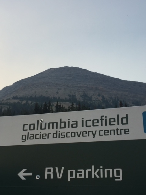
Columbia Icefields Sign
Traveling south, all of the campgrounds were full and had limits to the length of the trailer or RV’s of 25 feet which meant the RV was too long to camp there if a site was available. There were people stopped alongside the road looking at a black bear eating berries and walking along down the hill from the highway.

Black Bear
The mountains were picturesque with their hanging glaciers and the ever present smoke from the nearby fires.
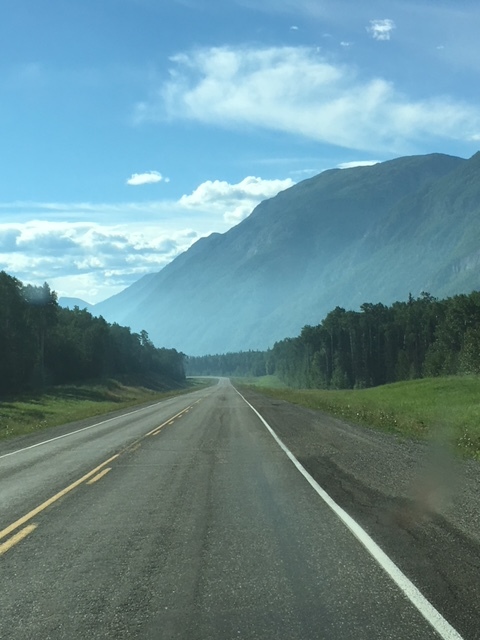
Lonesome Highway
After a couple hours of driving, we came upon a big parking area where about fifty RV’s and trailers were parked. It looked like everyone had their tables and chairs out and was staying overnight. We pulled in and asked a couple cooking dinner if overnight camping was ok and were told to go up to the information kiosk, fill out the paperwork and pay the $15 fee to stay there.

Camping Spot in front of Glacier
Once parked and set up for the night, it was early evening and the setting sun gave an Alpenglow to the surrounding mountains through the smoky haze.

Alpenglow
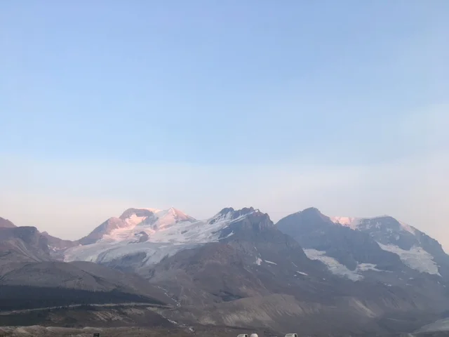
There were about 5 or 6 glaciers on the mountains above and the Athabasca Glacier right in front of where we were parked. It is one of the Canadian Rockies’ most beautiful and fascinating sights as you can hike up to the face of the glacier. The Columbia Icefield is a huge and barren desert of snow, ice and rock straddling the Continental Divide to the west and the Banff / Jasper National Park boundaries at their north and southern ends respectively. It is the largest icefield in the Rockies. It is large, intimidating and dangerous. There are 8 major glaciers including the Athabasca, Castleguard, Columbia, Dome, Stutfield, Saskatchewan, Wales and one more that I can't find, for some reason. There were stations just down from the hotel and information center that had signs with arrows pointing to the glacier, giving its history and people who had explored the area.
Spending the night under this canopy of glaciers was truly a bucket list thing to do. It was an unexpected and unplanned part of the trip as there were no camping reservations today, like many other nights.

Panorama View for the night
The beauty of the mountains, the setting sun, and the magnificent stars appearing as the sky darkened, from the pinkish/golden alpenglow changing to the purplish hues as night approached was inspirational.

Sunset Smoke
It was a totally unique setting shared silently with about fifty other RV’s who were stopping there for the night.
Friday - Other than the smoke, the day dawned beautifully with crispness in the air and no clouds, to speak of, in the sky. People were milling about making breakfast, getting ready to hike up to the glacier’s edge or hit the road to either Jasper to the north or Lake Louise and Banff to the south. This trek heading south through the Canadian Rockies had several “Oh Wow” moments as the lakes, glaciers, and animals along the way made for an interesting drive to Lake Louise.

On the Road

A River Runs Through It
As in Jasper, Lake Louise was full of people, traffic, and park employees directing traffic all through town.

Lake Louise Sign
We headed up toward the Fairmont Chateau Lake Louise but all of the lots were full so were directed back down the mountain to the east of town to the overflow parking area. Arriving, the lots looked quite full but after entering the RV parking area which was full by the time it took to turn around and head out of the parking lot another RV started backing out of its space. How lucky is that? Parking and catching the shuttle to town was pretty easy. It dropped us off right where we had driven earlier only to be turned around and told to go to the overflow lots.
As we walked down through the trees to the Lake, there many people milling about, laughing, talking, and small children chasing each other around. There were several hundred people there, so keeping the kids in line and within sight was probably nerve wracking for some. The smoky haze covering the mountains and the lake impeded the beautiful views of the glacier on the far side of the lake, as well as, those hanging onto the other mountains surrounding the lake.

Lake Louise
There were people from many nationalities taking photos and talking with the rangers who were giving talks about the area.
Surrounded by soaring mountain peaks, the majestic Victoria Glacier and a glistening emerald lake, the iconic Fairmont Chateau Lake Louise hotel is located in Alberta's Banff National Park.

Flowers at the Hotel
We walked over to the Fairmont Chateau Lake Louise for lunch. The majestic lobby bears the perfectly preserved grandeur of yesteryear. Adorned with oil paintings, polished wood and plush carpets, the space is capped with a chandelier and a grand staircase straight out of a Victorian novel. The lobby opens onto the iconic Lakeview Lounge, with its majestic plate glass windows and remarkable view of the lake and glacier. Lunch was great but crowded with many of us that were not hotel guests eating in the non-guest cafe. The staff was very attentive to the food and drink selections and recommended several choices.
The walk back around the Lake’s edge and through the trees to the shuttle bus depot was nice. More shuttles arrived, bringing in new people as we left the Lake Louise area. It did not take long to make the drive. We had the same driver going back as we had bringing us up earlier that day. It was funny watching him blow his horn in traffic and at the park employees directing traffic. He was a hoot and you could see he enjoyed his job as he talked with those he honked at.
The road to Banff was an easy transition from Lake Louise but the road into town to find fuel proved to be a little more interesting. There were not many gas stations within town so we were stuck with whatever price was posted. The smoke was horrible and visibility was so limited that driving to Canmore, Alberta was not worth the extra drive time since we would not be able see anything. Canmore is a beautiful town with mountains all around and was the setting for several movies including: “Mystery, Alaska” and “Last of the Dogmen”.
Driving from Banff on highway 93 through Kootenay National Park once you crossed over the mountain close to Kootenay Crossing there were two very active forest fires burning several miles apart. There were about four helicopters and fire crews working each fire, the helicopters would swoop into the river or small pond, draw water and head out to drop it onto the raging fire. With four choppers working the fire, one was dropping water on the fire, another was drawing water from the river, and the other two were flying back to get additional water or toward the fire to make another drop. Fire crews used pumps in the ponds and river to draw water and used hoses and sprinklers to cool down the hot spots.
Driving along the second fire the helicopters were literally dropping their water next to the road with it splashing up on the RV as we drove by. You could feel the heat, smell the smoke, and hear the sound of the rotor blades from the helicopters swirling so closely above that it made for a tense few minutes transitioning through the fire area. I was surprised that the road was not closed but the fire crews were working it and keeping it away from the highway. They did a great job of containing the flames to an area farther up the mountainside. When we arrived at the campground, we found out the road had been closed to traffic shortly after we drove through the area.
Once past the fires and climbing the highway toward Radium Hot Springs there was an overlook that showed another major fire just on the backside of the mountain from Banff. It was another major fire but did not look like it was being fought with assets working the other two fires nearby.

Banff Fire Smoke
It seems like the trip has been in smoke for over a month now with the exception of the time in Alaska. You could see smoke further west past Denali but it was not over you while there.
The day ended in Jaffray, British Columbia in the Golf Course RV Park alongside a small river. The camp hosts gave me a golf cart which allowed me to go over to the clubhouse and post one of the blogs about Alaska since the internet connection at the campsite was very weak. It became dark; I had no headlight or flashlight to find my way back driving alongside a small pond. Luckily, just after I finished posting the camp host came looking for me with flashlights to find our way back in the dark. It had been another long day of driving. Tomorrow, we would be crossing the border back into the US and any surprises that will bring, while Traveling Life’s Highways.