
Yellowstone National Park - Day 2
Wyoming
Tuesday, August 14, 2018
Smoky, 86°
“Climb the mountains and get their good tidings. Nature's peace will flow into you as sunshine flows into trees. The winds will blow their own freshness into you, and the storms their energy, while cares will drop away from you like the leaves of Autumn.” – John Muir
The morning broke with the sun shining through the trees; the smoky haze that had covered most of the western United States was still in full force creating a blurry mist from horizon to horizon. It was clear above with blue sky but as you looked toward the horizon in any direction, the view was limited to only a mile or two. Without the smoke it should have been for miles.
There were no shower or laundry facilities at our campground so had to go to Fishing Bridge campground, as this is where the park’s showers were located. It took a little time to get there since the road leading to that site was under repair. Finally, we were ready for the day’s exploration of the park!
A little past LeHardys Rapids, the road leads to the parking lot for the Mud Volcano. There were many people walking along the trails around the features. I was imaging something like Krakatoa: a massive cone, spewing muddy material. I was a little disappointed pulling into the Mud Volcano area only to find that the “volcano” is nothing more than a giant pit which, granted, is muddy.

Mud Volcano - (I know a let down for me too)
The eastern half of Yellowstone National Park has two geyser areas, Mud Volcano and West Thumb Geyser Basin. The two offers an outstanding contrast: where West Thumb is known for its relative tranquility and limpid waters, Mud Volcano’s fame rests on its boisterousness and acridity.
Most of the best attractions in Mud Volcano are located just outside the parking lot. The Mud Cauldron is view-able from the pathway right in front of the parking area. It is a large area of mud and water heated by steam escaping from far below. As you head left from the parking area toward a steep climb, a short side path leads to the Blood Geyser.

Blood Geyser
The sign said this feature used to “erupt” muddy water up to 50 feet in the air in the 1800s. It has long since stopped this activity and, at present, is a sizzling mud pot area.
Continuing up the pathway, climbing the Cooking Hillside, which is quite steep but relatively short.

Cooking Hillside
The boardwalk trail resumes at the top and soon comes to the Churning Cauldron.

Churning Cauldron
This area was a cool pool filled with bacteria until earthquakes in 1978 and 1979 greatly increased the temperature. It tosses muddy water three to five feet high. Further ahead, at the top of the hill, the boardwalk goes to the left and right. To the left is a short side path leading to the Black Dragon’s Cauldron. It is a large, sizzling lake of mud. It was created in 1948 along a crack in the earth, and coated nearby trees in mud when it exploded into existence.
Return to the main boardwalk and take the right turn back downhill towards the parking area. A short distance down the walk is the Grizzly Fumarole.

Grizzly Fumarole
This feature’s appearance varies widely depending on recent precipitation. It can be a watery mud-pot, a thick mud-pot, or simply a steam vent (fumarole).
At the bottom of the hill almost to the parking lot is Mud Volcano and a short side boardwalk leads to the Dragon’s Mouth Spring. A favorite for many, it has nothing to do with mud. I thought it was one of the more interesting features in the park.
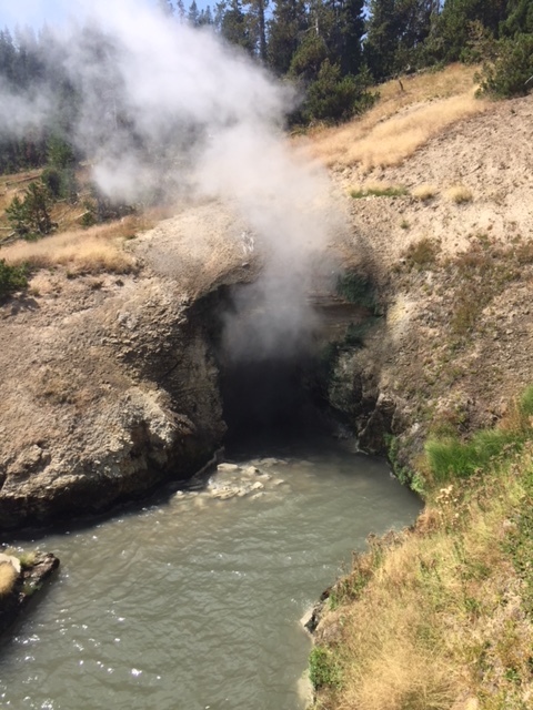
Dragon’s Mouth
It’s a spot where boiling water has gradually eroded away the hillside, creating a cavern that resounds constantly with roaring waters — almost like there really is a dragon lurking in there. Bizarre noises emit from the opening, making the idea of a dragon’s mouth rather believable.
Continuing north on the loop road you come to Hayden Valley where bison and elk free range on both sides of the road. The Yellowstone River winds along its way with rolling hills giving scenic views over each hill. We saw several bison herds grazing in the distance. Closer to the road, there were some individual bulls. One, standing at the base of a small cliff had gathered quite a crowd of photographers and others that wanted a close up view. It was easy to get great pictures from above the bison.
The Canyon Village area is one of the most majestic areas found within the Park boundaries. More photos and paintings are done here of the vast breathtaking views along the canyon’s edge of the deep canyons. With the Grand Canyon of the Yellowstone River featuring two breathtaking waterfalls, a vast canyon lined with yellow cliff walls, and a number of viewpoints and hiking trails, there is something for everyone.

Upper Falls of the Yellowstone River
The walk down to Artist viewpoint is well treed with breaks giving amazing views of the canyon walls, the river below and from several vantage points, the Upper and Lower Falls cascading into the canyon far below.

Lower Falls of the Yellowstone River
Along with Old Faithful, it’s one of the park’s two marquee destinations. Seen from above, the canyon looks like the earth itself has a loose seam: A 20-mile-long, sheer-sided gorge plunges more than 1,000 feet to the Yellowstone River, widening up to 4,000 feet across in places.

Yellowstone Canyon
Two thundering waterfalls pour over two immense drops in the river’s course, and a palette of bright reds, yellows, orange, whites, and browns swirls cross the rocky walls. In short, it’s every bit as impressive as that other Grand Canyon, if not quite as big.
According to the ranger discussing the early exploration of the park, the first reports of Yellowstone, in the early 1800s, described a place in the northwest corner of the Wyoming Territory where mud boiled, water spouted, and steam came out of the ground. The area in question was at the headwaters of the Yellowstone River, the longtime home of a band of Shoshone Indians. In 1807, John Colter, a former member of the Lewis and Clark expedition, met with ridicule when he first described the fantastical place. People then jokingly referred to it as "Colter's Hell."
Ferdinand V. Hayden, head of the U.S. Geological Survey of the Territories, decided it was time for professional explorers to take a look. In 1871, Hayden led an expedition to Yellowstone to determine the real value of the land. The expedition party consisted of a botanist, zoologist, mineralogist, meteorologist and a team of topographers who were there to collect scientific data about the landscape. Also accompanying them was a young artist named Thomas Moran and a photographer. For the first time, Americans were able to see what mere words had previously described. (NPS Ranger talk)
The day ended at Tower Fall and Tower-Roosevelt. Located in the northeastern part of Yellowstone near Tower Junction, the fall plunges a stunning 132 feet.

Tower Falls
The unusual rock columns north of the fall were created by lava flow that cracked as it cooled. It was just over an hour’s drive back to the campground where a small waterfall was alongside the roadway.

Small Waterfall along Roadway
Back at the campsite, a great dinner with a campfire under the night skies ended the day.