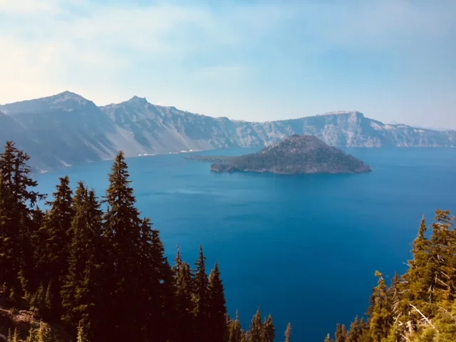
Crater Lake, Oregon
Saturday, July 07, 2018
Smokey, 65°
"I thought I had gazed upon everything beautiful in nature as I have spent my years traveling thousands of miles to visit the beauty spots of the earth, but I have reached the climax. Never again can I gaze upon the beauty spots of the earth and enjoy them as being the finest thing I have ever seen. Crater Lake is above them all." - Author Jack London, 1911
Driving from Northern California, the several campsites along this stretch of road that I wanted to camp in was full. We continued up the coast to Crescent City, California. Highway 101 leaves the ocean and heads northeast into Oregon. There were still some old stand redwood groves I wanted to see (Howland Road) but RV’s are not permitted to drive there due to their size. Leaving the redwoods behind, we crossed I-5 at Grants Pass and made our way across south-central Oregon to Crater Lake National Park (CLNP).
Crater Lake Sign
The scenery is beautiful as it transitions from the redwood forests to the volcanic stone in this part of the state. Unfortunately, the smoke from the Northern California wildfire was blowing to the northeast across south-central Oregon including CLNP.
This was my fourth attempt to look down into Crater Lake and actually see something, as on previous trips the weather was foggy. During the last visit on July 10, 2016 on my way from Alaska, it was snowing and foggy limiting views to about 10 feet or less in front of you. Today there is not a cloud in the sky but high smoke is drifting across the area. It is far above the mountain so it should not be a problem to see what is down inside this big hole in the earth. The climb in elevation from the ocean to the crater’s rim is gradual until that last twenty miles then the road and its switchbacks get steeper. I did not realize it was over 6,500 feet ASL and it has been estimated that Mount Mazama was over 12,000 feet ASL before it blew and fell creating Crater Lake.
View from Visitor’s Center
Crater Lake is a caldera lake in south-central Oregon. It is the main feature of Crater Lake National Park and is famous for its deep blue color and water clarity. The lake partly fills a nearly 2,148-foot deep caldera that was formed around 7,700 (± 150) years ago by the collapse of the volcano Mount Mazama.
Blue Water
There are no rivers flowing into or out of the lake; the evaporation is compensated for by rain and snowfall at a rate such that the total amount of water is replaced every 250 years. With a depth of 1,949 feet, the lake is the deepest in the United States. In the world, it ranks ninth for maximum depth, and third for mean (average) depth. The lake is 5 by 6 miles across, with a caldera rim ranging in elevation from 7,000 to 8,000 feet and an average lake depth of 1,148 feet. The lake's maximum depth has been measured at 1,949 feet, which fluctuates slightly as the weather changes. Crater Lake features two small islands.
Vista View
Wizard Island, located near the western shore of the lake, is a cinder cone approximately 316 acres in size. Phantom Ship, a natural rock pillar, is located near the southern shore. (Wikipedia)
Wizard Island
As you go around the rim walkway, it is interesting to see the Mazama ash with its reddish/orange color clinging to the inner and outer sides of the rim walls.
Mazama Ash
Rock slides had exposed the ash in multiple places and large boulders that had been tossed up also clung to the walls of the crater. Wizard Island, to the west end of the lake, rises out of the deep blue waters and is almost as high as the crater’s rim.
Bird in tree
The volcanic cone was clearly visible even with the smoky haze.
Smokey Haze
From another viewpoint, you were just above and closer to the cone, easily seeing the remnants of old lava flows down to the water. There was still some snow in the shadow portions of the inside walls which was surprising since it was the middle of July.
Mt. Scott
Mazama campground was full so we came down the mountain and left the Park on the north side. Was a drive into Portland tonight in the works? It would take another four hours which would make for an even longer day of driving. We continued on for a couple of hours and stopped at a nice campground in Redmond, Oregon. In the morning, there would be a short two, or so, hour’s drive past Mt. Hood into Gresham.
Total drive for the day was from Fortuna, California to Redmond, Oregon by way of the Pacific Coast, the Giant Redwoods, and Crater Lake while Traveling Life’s Highways.


