Monument Valley
Arizona/Utah
Saturday, June 9, 2018
Clear, 90°
“In the Navajo culture each of these mesas and buttes, they have heartbeats.”
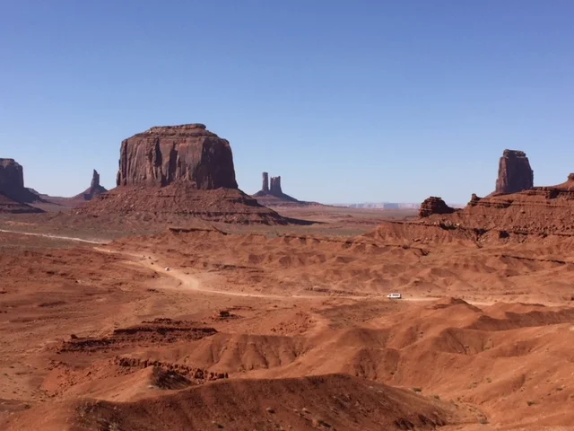
Monument Valley provides perhaps the most enduring and definitive images of the American West. John Ford used the isolated red mesas and buttes surrounded by empty, sandy desert in several classic western movies. It has been filmed and photographed countless times over the years for movies, advertisements and holiday brochures. Because of this, the area may seem quite familiar, even on a first visit, and it is soon evident that the natural colors really are as bright and deep as those in all the pictures.
In the movie Forrest Gump, the scene where he stopped his several year run was filmed at mile marker 13 just north of the Utah/Arizona State line.

End of Forrest Gump Run

Mile Marker 13 looking toward the Valley
There is a very nondescript sign, just off the road, showing the spot but one would have to know where it is since it is not marked anywhere near the road.

Forrest Gump Sign off the road 80 feet
The valley lies within the territory of the Navajo Nation Reservation and is accessible from U.S. Highway 163, which links Kayenta, AZ with US 191 in Utah. The stretch approaching the AZ/UT border from the north gives the most famous image of the valley, and possibly of the whole Southwest - a long straight empty road leads across a flat desert towards the 1,000 foot high stark red cliffs on the horizon, curving away just in front. The highway cuts through the mesas at Monument Pass.
Standing right before us are three of the most recognizable “monuments” known as Merrick Butte and the two hand-shaped East and West Mittens. But if a monument is something left behind to commemorate the dead then maybe it’s a misnomer here.

The Left and Right Mittens and Merrick Butte
The valley is not a valley in the conventional sense, but rather a wide flat, sometimes desolate landscape, interrupted by the crumbling formations rising hundreds of feet into the air, the last remnants of the sandstone layers that once covered the entire region. The area is part of the Colorado Plateau. The elevation of the valley floor ranges from 5,000 to 6,000 feet above sea level.
The view from Lookout Point is spectacular enough, but most of the Navajo Tribal Park can only be seen from the Valley Drive, a 17 mile dirt road which starts at the visitor center and heads southeast though the towering cliffs and mesas, one of the most famous being Totem Pole, an oft-photographed spire of rock 450 feet high but only a few meters wide. Clint Eastwood used this in his move The Eiger Sanction with George Kennedy. Taking the tour, Darren, the guide, said Eastwood was dropped off on the top by helicopter and did not make the actual climb up the spire.

Totem Pole Spire
The road is dusty, steep and rather uneven in a couple of places. It does not require 4WD - unless there has been a recent heavy rain, the journey is suitable for the majority of family cars, but I would not recommend it for any RVs, as the road has deep ruts and some deep sand in which you easily get stuck. Perhaps, the surface is not improved too much in order to increase business for the many Navajo guides and 4WD jeep rental outfits, which wait expectantly by the visitor center - typical prices are around $75 for a 2 hour trip (though cheaper tours are available from Gouldings Lodge). They gave a great tour going back well into the reservation past the normal places on the 17 mile tour. There were eroded rocks, ancient cave and cliff dwellings, natural arches and petroglyphs, all generally away from the Valley Drive at more isolated locations and viewable only as part of guided tours. We saw many locations and were not rushed by the guide, Darren who was extremely knowledgeable about his reservation, the customs and legends of the region.
There was this big bowl looking arch that had beautiful colors and once you walked to the back wall and lay on your back looking straight up at the hole in the arch you could see the image of an eagle’s eye, beak, and head feathers.

Eagle Eye Bowl

Eagle Eye Head and Beak
We stopped at John Ford’s Point where the film maker directed movies like Stagecoach; She Wore a Yellow Ribbon, and The Searchers. The view from the point gives you a great view of the landscape used in the movies.
The West and East Mitten Buttes along with Elephant Butte make up the very iconic photo of the mesa which was used in the John Ford movies.

View from John Ford’s Point
Darren showed us the cave where John Wayne was “holed up” at the end of the movie The Searchers and where he rescued Debbie.

John Wayne Cave from The Searchers
Making your way past the road traveled on the 17 mile road loop gets you into the back country of the Navajo Reservation where horses run wild (it was hot so they were only grazing) and cows used any rock outcropping or small cave for shade. There were centuries old pieces of pottery on the floor of caves and on the ground just outside in several places. It was eerie but so interesting to see that these had not been disturbed. On the Navajo Nation, all of the land is sacred so the children and others do not mess with or destroy these artifacts of their history.

Centuries old pottery fragments
You could pick it up look at it and return it to the earth where it has been for centuries if you wanted but it was perfect to just get close and snap a photo.
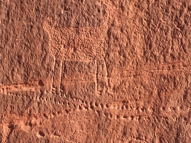
It was glorious to see the petroglyphs and pictoglyphs on the walls of some buttes and cave entrances up close. There were five or six that were accessible and easy to view.

Antelope drawing on the walls

Human like Figure on wall
Wall Drawings

Thunderbird
The tour ended with viewing Sun Arch where you got out of the Jeep, walked several hundred feet up to a spot where you looked at the Sun Arch through the Y branches of a dead Juniper Tree.

Sun Arch
The Tour based from Gouldings Campground was excellent; stopping at many viewpoints, giving the history of the Navajo Nation, and explaining those special places that are held in esteem.
It was hot, dusty, bumpy, but a great way to spend almost four hours totally immersed in the culture and mystique of this beautiful area.