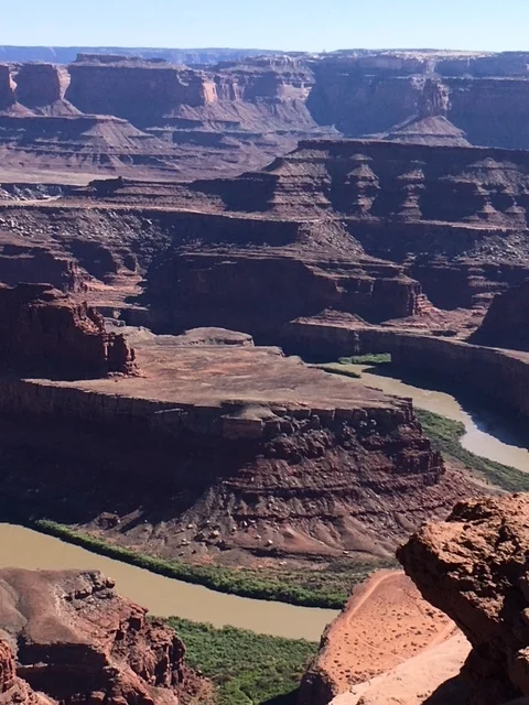
Dead Horse Point/Canyonlands National Park
Moab, Utah
Friday, June 8, 2018
Clear, 95°
“Let your memory be your travel bag.”
The Legend of Dead Horse Point
According to one legend, the point was once used as a corral for wild mustangs roaming the mesa. Cowboys rounded up these horses, herded them across the narrow neck of land and onto the point. The neck, which is only 30 yards wide, was then fenced off with branches and brush, creating a natural corral surrounded by precipitous cliffs. Cowboys then chose the horses they wanted and for reasons unknown, left the other horses corralled on the waterless point where they died of thirst within view of the Colorado River, 2,000 feet below. (Info from Park Brochure)
Dead Horse Point State Park Sign
I participated in a World Invitational Hang Gliding Championship in Moab, Utah in 1978 and 79 at Dead Horse Point State Park.
Horseshoe Bend on the Colorado River
A local pilot, Greg Duhon put the meet together with the Park and forty pilots were invited from around the world but only 33 were allowed to fly. I place second in 78 and third in 79 both great years. The elevation at the takeoff point is 5,900 feet above sea level.
Returning, I was anxious to see what had changed and how it would look after so many years. It was a very strange place to fly as there were no take-off ramps to run off to start your flight. There were three different rocks in several directions to leap off of, (with 2,000 vertical feet to the valley floor below),
1978 Hang Gliding Photo of the leap
Free falling the first hundred feet until the glider had enough lift to fly.
Takeoff Rock today
2,000 vertical feet drop
The rest of the flight was almost magical with the Colorado River winding its way around Horseshoe Bend and the monolith spires and steep cliff walls on three sides.
1978 Photo in flight
A look at Takeoff Leap into Flight
Back then, I professionally flew and managed Francis ”Tut” Woodruff’s Hang Gliding Team, called Tut Fliers. She was part of the Coca Cola Woodruff family and owned Hang Glider Heaven in Clayton, Georgia. We competed in hang gliding championships all over the world and Tut traveled with the team on many occasions along with her best friend and photographer, Lois Zachary, who took photos for Tut and hang gliding magazines.
Doug Heath, Tut Woodruff, D. Whittington at Dead Horse Point set up area
To describe it, is something like this: from the prominence of Dead Horse Point, 2,000 feet above a goose-neck in the Colorado River, an ever-changing landscape unfurls. There are immense vertical cliffs that meet with canyons carved by ice, water and wind over thousands of years creating a visual masterpiece. The mesa top is barren of trees. Plants and animals barely survive facing many challenges and extreme conditions within this high desert environment. There are many stories of ancient hunters, resting along the cliff tops while knapping chert in preparation for the next hunt, and cowboys of the late 1800’s, chasing wild mustangs onto Dead Horse Point, using the narrow neck to block off the natural corral.
It is still vast and beautiful here with the vibrant blue greens of the potash ponds contrasting with the red and cream colors of the desert floor below.
Potash Ponds almost 20 miles away - In the Vastness Distance & Depth Perception skewed
The Park has created walls around the old takeoff area and covered part of it with a pavilion where we once set up our gliders. The rocks we used to leap off are still there behind the wall that runs the perimeter around the point.
I have to admit it was a little unsettling to look down over the wall at the 2,000 foot vertical drop without wondering how crazy I was in my youth to leap off this cliff into the unknown.
Selfie at the Rock
As the afternoon wore on, it was time to leave Dead Horse Point (DHP) and turn west to Canyonlands National Park.
Canyonlands National Park Entrance
The entrance is only a couple miles down the road from the DHP turnoff and once inside the road winds its way around to many viewpoints to look at steep cliff canyon walls, monoliths, miles and miles of desert and at the farthest point in the park a “Grand View” of the canyons carved by the Colorado River below.
Rock Mesa's and Canyons below
The sun was low on the horizon to the west creating nice colors on the walls to the east.
It is like another Grand Canyon in the Distance
While at Grandview Overlook there was a bicyclist who pulled in at the same time. It was time to give the tired rider a nice cold bottle of water which he appreciated very much. I found out he had been on the road for two years already. He started his trip at the southern tip of South America and was riding northward every day. He was in southeastern Utah slowly making his way north to Alaska with Prudhoe Bay, at the top of the world, his final destination. He thinks he will make it in another year and must time his ride through Canada and Alaska to make it when there is no snow. He was traveling light with only a small backpack containing a water canister and two side bags on his bicycle. He was lean with not an ounce of fat on his body, using everything to peddle up to a hundred miles a day. It was pretty neat meeting and talking with him.
It was an interesting day revisiting places I had traveled in my youth and the memories it brought back. Just like good music, it floods your consciousness with all the people from that time, the great times had, and the fantastic hang gliding in a unique and fabulous setting.


