Mount Rushmore National Monument
South Dakota
Saturday, August 18, 2018
Thunderstorms, 82°
And in the end, it’s not the years in your life that count.
It’s the life in your years. ― Abraham Lincoln
Driving from Devils Tower to Mount Rushmore seemed like it would be an easy day that would lead through the old west town of Deadwood (HBO’s series) and nearby Sturgis, famous for its motorcycle rally held each year the first week of August. But quickly, the weather changed as a massive thunderstorm covered both towns. There was heavy rain, lightning with loud thunder rolling across the landscape and hail falling, hitting the RV covering and the ground like snow.
As we approached the storm there was a group of four motorcycles, each with two people on them, who were ahead of the RV. They appeared to be debating whether to get off the freeway to seek shelter under a bridge with one or two motorcycles putting on their blinkers for the others to follow. The ones trailing passed the other two cycles and all four continued into the storm just ahead. They would soon find out that was a bad choice not seeking shelter as they, along with a similar RV, headed into the wall of rain just ahead.
You could see that everything went almost nighttime dark after driving under the large dark cloud. There was heavy rain that looked like a solid wall of water about a mile in front of this group. A few large raindrops hit the windshield as the group of vehicles approached the storm. Everyone started to slow down as you could tell looking ahead, that the visibility was cut down to what would be a “whiteout” condition in Alaska. Speeds went from 65 mph to about 25 as we entered this literal wall of water blasting the roadway. The water droplets turned into very large drops hitting the windshield and almost totally obscuring any view.
The motorcyclists were in the right lane while we and the other RV were driving in the left lane next to the center median. Everyone slowed to a crawl, emergency flashers blasting light through the now non-discernible landscape. The rain pounding down on the windshield and camper top created a loud noise when suddenly it was deafening as hail started bouncing off things. The hail was about two inches in diameter. The motorcycles were alongside us now and everyone was trying to see the other vehicles beside or in front of one another. There were no bridges or exits to provide cover from the storm so everyone kept creeping along hoping others behind us were not speeding into the slow moving traffic. If they were smart they would have slowed to a crawl, too.
After a few minutes, an exit appeared and the motorcyclists were heading for cover under the bridge of the exit ramp. I am sure they felt the sting of the hail and the pounding the rain against their bodies and face masks and were glad to finally be able to stop and get to safety in this massive storm.
The other RV and I continued up the freeway, flashers blasting, as we made our way through the storm. First, we went past the Deadwood exits with the hail beating like a drum on the hood, windshield, and top of the RV. It was raining so hard and were so close to the other RV in front of us that if it went off into the ditch we would have been right behind it. After about ten minutes, the hail let up and got smaller. The heavy rain continued for almost an hour as the Sturgis exits came and went dousing any hopes of seeing either of those two towns.
The thunderstorm finally let up as we approached Rapid City where it was time to refuel. I was glad not to have to do it in the pouring rain and hail but the clouds were still very dark and depending on the storm’s movement, it could start to rain here shortly. Getting back to an interstate highway after being in Canada so long brought with it the opportunity to use the Flying J/Pilot gas card once again. This gas card for RV’s gives five or six cents a gallon off the price displayed on the large signs of the truck stop.
Rapid City had grown since my last visit with construction projects going on all around. The freeway was getting its summertime makeover as we climbed the hill in town, heading south on highway 16 towards Keystone. There were several tourist places to stop along the way with Reptile Gardens, Bear Country USA, and the American Buffalo Resort to pique the interests of visitors.
The town of Keystone had grown exponentially from my last visit. There was a stretch of road several miles long with all kinds of shops to entice tourists. As it wound its way down and around the curves running through the town, we saw lots of people everywhere. Traffic slowed to a crawl as people walked out in front of vehicles, ignoring any crosswalks. Keystone had a touristy feel much like Gatlinburg, Tennessee but with an Old West theme. There were museums, The National Presidential Wax Museum and the Borglum Story museum of how Mount Rushmore came into being but for me it was sad to see so much growth that it took away from the quaintness I had seen previously. I think in this present time “less is more” would have been better.
You veer off Iron Mountain Road (16A) and climb in elevation on highway 244 as you approach the entrance and parking for Mount Rushmore National Memorial.

Mount Rushmore Sign
Everyone pays a parking fee as the senior pass for the Park Service only allows you into the Memorial. RV parking was just off the side past the main parking area and only a short walk up the hill to the main viewpoint of the Memorial.

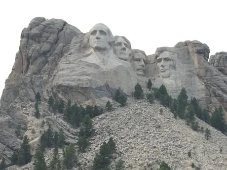
First View of Mount Rushmore from parking area
The southeastern face of Mount Rushmore in South Dakota’s Black Hills National Forest is the site of four gigantic carved sculptures depicting the faces of U.S. Presidents George Washington, Thomas Jefferson, Abraham Lincoln and Theodore Roosevelt. Led by the sculptor Gutzon Borglum, work on the project began in 1927 and was finally completed in 1941. Over that time period, some 400 workers erected the sculpture under dangerous conditions, removing a total of 450,000 tons of rock in order to create the enormous carved heads, each of which reached a height of 60 feet (18 meters). In sculptor Gutzon Borglum’s original design, the four presidents were meant to be represented from the waist up, but insufficient funding brought the carving to a halt after completion of their faces. Known as the “Shrine of Democracy,” Mount Rushmore welcomes upwards of 2 million visitors every year, and is one of America’s most popular tourist attractions.
Seeking to attract tourism to the Black Hills in the early 1920s, South Dakota’s state historian Doane Robinson came up with the idea to sculpt “the Needles” (several giant natural granite pillars) into the shape of historic heroes of the West. He suggested Red Cloud, a Sioux chief, as a potential subject. In August 1924, Robinson contacted Gutzon Borglum, an American sculptor of Danish descent who was then working on carving an image of the Confederate General Robert E. Lee into the face of Georgia’s Stone Mountain. Luckily for Robinson, the headstrong Borglum was on the outs with the group that had commissioned the Lee sculpture, and would soon abandon the project.
Borglum suggested that the subjects of the South Dakota work be George Washington and Abraham Lincoln, as that would attract more national interest. He would later add Thomas Jefferson and Theodore Roosevelt to the list, in recognition of their contributions to the birth of democracy and the growth of the United States.

Faces of our History
On July 4, 1930, a dedication ceremony was held for the head of Washington. After workers found the stone in the original site to be too week, they moved Jefferson’s head from the right of Washington’s to the left; the head was dedicated in August 1936, in a ceremony attended by President Franklin D. Roosevelt. In September 1937, Lincoln’s head was dedicated, while the fourth and final head–that of FDR’s fifth cousin, Theodore Roosevelt–was dedicated in July 1939. Gutzon Borglum died in March 1941, and it was left to his son Lincoln to complete the final details of Mount Rushmore in time for its dedication ceremony on October 31 of that year. Mount Rushmore National Memorial, known as the “Shrine of Democracy,” has become one of the most iconic images of America and an international tourist attraction. In 1959 it was made even more famous as the scene of a climactic chase scene in Alfred Hitchcock’s “North by Northwest.” (history.com)
Symbolizing the ideals of freedom and democracy it represents not only the past, but also a promise for the future. The stonework in the Avenue of Flags is nice, providing a great contrast as one view the four heads on the mountainside with the flags on either side of the faces.

Avenue of Flags
As you walk up from the parking areas prepare to stand in awe of this magnificent mountain when you enter the Memorial via the Avenue of Flags, showcasing flags from all 50 U.S. States and U.S. Territories. The Grand View Terrace, a large granite viewing platform features seating and plenty of places for photographs. It was filled with people but did not seem crowded with everyone having room for that selfie photo or just standing around looking at the carvings on the mountainside, the flags, the trails, or the amphitheater in front of you. It seems to have that reverence about it much like the Lincoln Memorial or Washington Monument in Washington, DC. There are elevators and stairs to take you down to the Lincoln Borglum Museum and amphitheater seating area where nightly lighting ceremonies take place. Probably the best time for photos at Mount Rushmore is in the morning with its southeastern facing direction but any time of day or night will give you a great photo of these American icons.
There is a hidden chamber behind Lincoln’s head. To accompany the faces, Rushmore’s sculptor, Gutzon Borglum, had ambitious visions of a repository with an entrance crowned by a bronze eagle, accessible by a grand staircase. Interiors were to be adorned with friezes, vaulted ceilings, busts, and bronze-and-glass cabinets that housed artifacts central to American democracy. The construction only got so far . . . a tunnel was blasted into the canyon . . . before it was abandoned. Though the unfinished Hall of Records remains off limits to visitors, it’s the bearer of a titanium-vault with porcelain panels outlining milestones in U.S. history. (travelandleisure.com)

Secret Room Entrance – Photo by National Park Service
Leaving Mount Rushmore we decided to bypass the Badlands and start the trek south towards Oklahoma. Spending another day in the Badlands did not seem all that exciting as we would be looking at rolling hills and more open land as we had seen for the last few days. The road south turned out to be long as we passed several interesting places along the way. One was Prairie Berry Winery making wines since 1876. The large sign for Red Ass Rhubarb wine with a big red donkey took us by surprise as we drove by and after several miles of laughter it was a shame that we did not get the chance to stop in for this surly fun wine tasting. Here is the story to this unique wine:

Red Ass Rhubarb Wine
“Too many cooks can spoil the stew, and too many helpers in the winery can change the course of history. In the early days Ralph, our winemaker’s dad, was helping out in the winery. He accidentally added elderberry to the tank for Razzy Rhubarb wine, which, at that point, was no longer Razzy Rhubarb wine.
The story goes that his face turned red and he felt like an ass for messing up the wine, so it became Red Ass Rhubarb. Add a donkey to the label and you’ve got the most famous, most award-winning wine made in South Dakota (we decided to leave out the elderberry in subsequent fermentation’s).” (There is more to this wine story coming shortly in another post.)
Another spot along the way became instantly familiar as we drove by the sign. Hemingford, Nebraska. For any Stephen King fan, he has used this Nebraska town in several of his novels and short stories. In his 1984 film “Children of the Corn” some of the residents in Hemingford would rather not be associated with the stigma of “He Who Walks Behind the Rows” while others are happy the community has gained distinction from the author’s work; dubious or not.

Hemingford, Nebraska
In one of my favorite books, “The Stand,” Hemingford Home, Nebraska serves as the home for the main character, Mother Abigail. She is 106 years old, outliving all her husbands, children and grandchildren and embodies “Good” in the story of good and evil in the book.
According to USA Weekend: “For King, fictional Hemingford Home is where the heartland is. And it’s named after the real Hemingford, NE. ‘I originally used Hemingford Home in The Stand,’ King says, ‘because I wanted to put Mother Abigail in the American heartland. That’s Nebraska. Hemingford was in the right place. … I love Nebraska and keep going back to it in my fiction — when I’m not in Maine, that is.’
It was pretty neat driving past “Hemingford Home” as another storm loomed up ahead. The rain started falling over the horizon and nearby corn fields when suddenly, a rainbow appeared reaching a full “pot to pot” arch over the cornfields. It reached across the sky from one side of the highway to the other and as we traveled down the road the rainbow continued to move down the highway in front of the RV, never quite getting to the proverbial pot of gold at rainbow’s end.
After the storm, it was drawing near to nighttime and we continued along the highway to Ogallala, Nebraska another town popular in another favorite book, “Lonesome Dove”.

Front Street Old town Ogallala, Nebraska
This is where Clara Allen’s horse ranch was located. Clara was Gus's former love. Her husband, Bob, suffered brain-damage after being kicked in the head by a mustang. After Gus‘ death; Captain Call, fulfilling Gus’ request brought letters to Clara and Lorena and took Gus’ body south to Texas to be buried in Clara’s orchard where they had picnicked when they were young. It would be several hours after dark before we arrived in Ogallala. After a refuel for the morning’s drive it was time to stop for the night in a little rest stop in Ogallala. There were many miles driven today while Traveling Life’s Highways, some popular places planned along the way while others were totally surprising. Not a bad day across America’s Heartland.